Seven diffusion and scientifically vulgarisation are planned:
Publication in Spanish of a scientific monographic in serial publication Trabajos del Museo Arqueológico de Ibiza y Formentera.
Publication in French of a scientific monographic in the Editions Errance (Paris).
Publication in English in a specialized scientifically revue.
A Vulgarisation documentary on Can Blai, in the setting of the Low Empire Mediterranean coast protection.
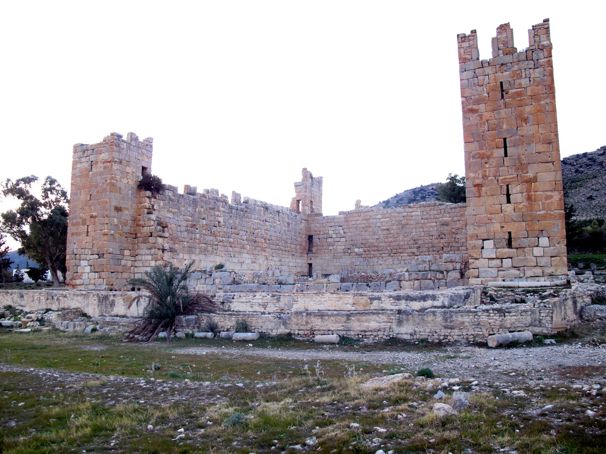
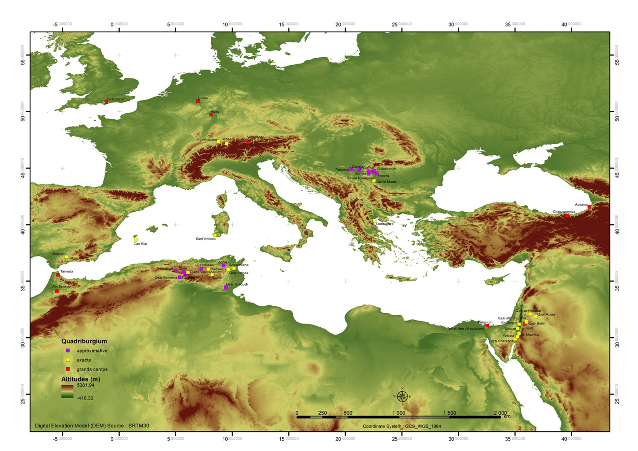 du bas empire et antiquité tardive
© G. Davtian & RGV » title= »Camps et fortins romains
du bas empire et antiquité tardive
© G. Davtian & RGV » class= »caption » align= »center » />
A web site exclusively dedicated to the Can Blai site.
Program of proceedings 2014
Can Blai, programme conferences-proceedings-conferencias 2014
2.07 – 10h
El registro arqueológico: la estratigrafía, el diagrama de Harris y el dibujo de objetos arqueológicos, por Ricardo GONZÁLEZ VILLAESCUSA, catedrático de Historia Antigua y Arqueología de la Universidad de Niza – Sophia Antipolis – UMR 7264
2.07 – 18h
Historia de la investigación en el yacimiento de Can Blai, por el Dr. Jorge Fernández, director del MAEF y co-director del proyecto Can Blai.
3.07 – 20h
Indiana Jones no es arqueólogo: la arqueología en el siglo XXI, por Emilie Comes Licence Professionnelle Guide Conférencier de la Universidad de Niza – Sophia Antipolis.
4.07 – 20h
20h – Utilisation de la lasergrammétrie dans le cadre de l’étude de Can Blai por Sabine SORIN, dibujante científico, CNRS-UMR 7264,.
20h30
Las cerámicas africanas del siglo III d.C., por Ricardo GONZÁLEZ VILLAESCUSA, catedrático de Historia Antigua y Arqueología de la Universidad de Niza – Sophia Antipolis – UMR 7264
7.07 – 20h
Can Blai: los resultados de la campaña de 2013, por Ricardo GONZÁLEZ VILLAESCUSA, catedrático de Historia Antigua y Arqueología de la Universidad de Niza – Sophia Antipolis – UMR 7264
11.07 – 20h
La péninsule Ibérique et les problèmes militaires du IIIe siècle, por Patrick Le Roux, Catedrático emérito de la Universidad Paris XIII.
15.07 – 20h
Le projet géomatique de Can Blai por Gourguen Davtian, ingenieur de recherche CNRS, (GIS, Télédétection, GPS) – UMR 7264.
16.07 – 20h
Un nouveau sens militaire du terme numerus, por Frédéric Gayet, Profesor de Historia Romana de la Universidad de Niza – Sophia Antipolis – UMR 7264.
18.07 – 20h
Romanización y municipalización de las Baleares, por María Luisa Sánchez León, Catedrática de Historia Antigua de la Universitat de les Illes Balears.
22.07 – 20h
El santuario púnico del Cap des Llibrell (Ibiza). Control y referencia para la navegación costera en torno a Ebusus por Joan Ramon Torres, Consell Insular de Ibiza.
24.07 – 20h
Le litus saxonicum (costa sajona), le système litoral et insulaire de protection au bas-Empire, por Raymond Brulet, Catedrático de la Universidad Católica de Lovaina – Bélgica.
29.07 – 20h
La integración de los castella en sus paisajes desde Mesopotamia a Spania en la antigüedad tardía, por Christopher Lillington-Martin, University of Oxford.
30.07 – 20h
Avance de la campaña de estudio de Can Blai 2014, por R. González Villaescusa catedrático de Historia Antigua y Arqueología de la Universidad de Niza – Sophia Antipolis – UMR 7264.
A cycle of public conferences during the ground works:
- A conference on the Research history on the Can Blai site by Jorge Fernández, excavations director from 1979 – 1980.
- A conference on « The fortifications and the Empire’s defence, under Diocletian (end of III century) by Michel Reddé, Professor of Roman Archaeology Ecole Pratique des Hautes Etudes Paris.
- A conference on the byzantine fortifications by M. A. Cau Ontiveros, BA, M.Phil, MA, Ph.D. ICREA Research Professor, Institució Catalana de Recerca i Estudis Avançats / Barcelona University.
- A conference on the state of knowledge advance on the site of Can Blai by R. González Villaescusa, Professor of Ancient History and Archaeology, Nice University Sophia – Antipolis.
- A conference on the Agrarian structures and Punic colonization in Ibiza (Baleares) by R. González Villaescusa, Professor of Ancient History and Archaeology, Nice University Sophia – Antipolis.
- A conference on the Landscape dynamics in the lower valley of the Argens (Fréjus, Var) from the Neolithic to the Roman period by Frédérique Bertoncello, CNRS-UMR 7642 – Université de Nice Sophia Antipolis
- A conference on the From Archaeomedes to ArchaEpigraph: archeology and spatial epigraphy to serve the study of the dynamics of population and ancient territories by Frédérique Bertoncello, CNRS-UMR 7642 – Université de Nice Sophia Antipolis and Marie Jeanne Ouriachi, Professor of Ancient History and Archaeology, Nice University Sophia – Antipolis.
- A conference on Roman pottery in the western Mediterranean in the third century AD by Alejandro Quevedo, Murcia University.
- A conference on Instability and transformations in the third century AD: Carthago Nova to Can Blai by Alejandro Quevedo, Murcia University.
- A conference on Villa and grotto of Tiberius at Sperlonga by Jean-Louis Paillet, CNRS – IRAA, Aix-en-Provence.
- A conference on Geomatics: Theory and Practice by Gourguen Davtian, engineer at CNRS, Geomatics (GIS, Télédétection, GPS) – UMR 7264.
Cultural mediation in July between the population and tourist. Regular visits in different languages will be organize.
Sala d’actes de l’àrea de Culturai Patrimoni de St. Francesc, av. Porto Saler s/n